Client: National Park Service Coastal Geology Program
Location: Nationwide
 The Coastal Geology Program of the Geologic Resources Division within the National Park Service (NPS) provides expertise to help coastal units within the National Park System address coastal geology, hazards, and climate change adaptation and resilience challenges. Through an on-call coastal engineering and hazards assistance task order, EA supports specific NPS needs, including:
- Coastal, natural, and cultural resource inventories and impact assessments
- Protection and planning for change in vulnerable low-lying coastal lands
- Monitoring of coastal change
- Protection and planning for impacts due to climate change
- Review of coastal engineering concept or design development, including natural and nature-based features, dredging, beach nourishment, and storm surge barriers
- Regulatory compliance documentation including for the National Environmental Policy Act
- Documentation and analysis of incident response and recovery
- Technical expertise to assist with associated training programs
Tasks have included:
 Bear Island Light Station; Acadia National Park, Maine—Storm surge has caused erosion and damage to the granite block foundation of the 1889 boat house. The team reviewed the site impacts and provided alternatives to improve resilience, including the completion of rough order of magnitude cost estimate for each alternative.
San Juan Island National Historical Park, Washington—Located on San Juan Island, which has long been inhabited by indigenous people, the park is experiencing erosion along several stretches that will require the development of shoreline protection, including the English Camp site along the northwestern edge of the island. Shoreline protection possibilities were developed and reviewed to identify options that could be implemented, considering the cultural and historic needs of the site. The EA Team assessed vulnerabilities due to sea level rise and provided a rough order of magnitude cost for shoreline protection options, which included nature-based solutions.
Coastal Shoreline Monitoring Options for National Park Units in the Great Lakes Area—Over the past two decades, the Great Lakes have undergone rapid changes in water levels, reaching historic low levels in the mid-2000s before rebounding to historic high levels in 2019/2020. Due to climate change, these water level fluctuations are expected to become more frequent and extreme. EA responded to requests for assistance in reviewing shoreline monitoring options for Great Lakes parks and facilitating related discussions about the objectives, pros, cons, and costs associated with each option—culminating with a report that outlined processes and potential techniques to effectively monitor shoreline changes in the Great Lakes.
College Creek Hydro-Geomorphic Assessment, Colonial National Historical Park, Virginia—Options for Colonial National Historical Park to reduce flow velocity where College Creek joins the James River were reviewed to assess adequacy and functionality of proposed management options. The team reviewed the hydrodynamic model output, which used the Semi-Implicit Cross-scale Hydroscience Integrated System Model.
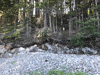
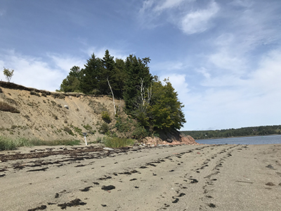 Saint Croix Island International Historic Site, Maine—Saint Croix Island has experienced continued erosion, and the southern bluff of the island is exposed to a significant fetch and tide range up to 24 feet that could impact grave sites of the 1604 French expedition members. EA conducted a site investigation for nature-based options to stabilize the bluff. Our team brought in the U.S. Army Corps of Engineers (USACE) Engineer Research and Development Center Engineering with Nature® initiative to provide additional resources and aid in additional data collection and consideration of nature-based adaptation options to help stabilize the eroding slope and account for sea level rise.
Various Coastal Review Services at Golden Gate National Recreation Area, California—EA’s services included:
- At South Ocean Beach, shoreline erosion is threatening the most seaward component of the Lake Merced Tunnel, a 14-foot diameter water pipe. Concept-level designs for a seawall construction were reviewed to assess projected impacts on the adjacent Fort Funston shoreline.
- An updated stormwater system was designed to mitigate flooding from Easkoot Creek at Stinson Beach. The preliminary design was reviewed to assess resiliency to erosion and climate change impacts.
- A recent beach boardwalk extension to enhance accessibility at Baker Beach was impacted by sand erosion, creating safety hazards. An updated design was assessed to determine if the new design would avoid future safety hazards in consideration of coastal processes and beach dynamics.
National Park Service Beach Nourishment Guidance Update, Nationwide—EA was tasked with supporting an update to the 2012 Beach Nourishment Guidance to improve procedures, strategies, and protocols. These updates will include expansion on discussion of impacts to nearby ecological resources, a high-level review of costs, coastal resilience considerations, and discussions on standard practices for beach nourishment in the planning, design, and construction phases, as well as other topics.
Fort Pulaski National Monument, Georgia—Located on Cockspur Island, the site is prone to flooding from coastal storms and king tides. The park’s Emergency Operations Plan was being updated, and the park needs to include a strategy to address natural and cultural resources in the context of emergency response and recovery actions. EA developed initial documents, including a checklist for natural and cultural resources and a post-event monitoring plan to address vulnerable resources and assets.
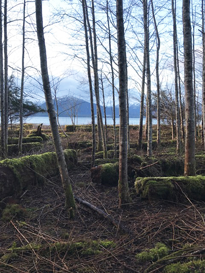
Sitka National Historical Park, Alaska—Restoration planning for the 1804 Battlefield bordering Sitka Sound may impact the tidal margin within the floodplain by removing beached logs and trees. These proposed actions were reviewed based on expected relative mean sea level changes and coastal storm surge to assess the level of risk for erosion associated with the project and whether additional data collection, calculations, or modeling may be warranted.
Gateway National Recreation Area, New York—EA reviewed flood mitigation technology, an environmental assessment for maintenance dredging, and modeling results for coastal resilience projects associated with the site. For the Jacob Riis Bathhouse, the park requested an evaluation of a proposed flood mitigation technology, including review of a flood barrier system under current and future sea level conditions. The team evaluated the USACE environmental assessment for adequacy and to assess if the proposed plan would negatively impact adjacent park lands. The park also requested a review of the USACE modeling reports that quantify impacts on sediment transport for a proposed storm risk reduction project for the Rockaway Inlet, the USACE proposal for initial beach nourishment, and development of project mitigation over the 50-year life cycle.