× ×

Who We Are

× ×

About EA

× ×

Careers

× ×

Subcontractors/Suppliers

×

Terrestrial Services

EA helps clients navigate complex terrestrial resource challenges by combining ecological expertise, regulatory knowledge, and practical problem-solving to support responsible land use, infrastructure development, natural resource management, and ecosystem restoration.

A Collaborative Approach to Natural Resource Management

EA believes successful outcomes are achieved through collaboration, proactive communication, and early engagement with regulators, communities, and project partners. We work closely with clients to anticipate challenges, identify practical solutions, and develop strategies that support both ecological sustainability and project success. This commitment to partnership, combined with our technical depth and nationwide experience, is what continues to distinguish EA’s terrestrial services practice.

Capabilities

Successful projects require a clear understanding of how natural systems function and how environmental requirements influence decisions. From early planning and permitting through construction and long-term stewardship, our scientists work alongside clients to identify opportunities, reduce project risk, and develop solutions that achieve environmental and organization objectives.

With more than five decades of experience across diverse ecosystems throughout the United States and territories, Guam, and other Pacific regions, EA brings a deep understanding of habitats, species, and regulatory frameworks. Our terrestrial ecologists have conducted biological surveys in environments ranging from Arctic coastal landscapes and western deserts to temperate forests, wetlands, and tropical island ecosystems. This breadth of experience allows us to provide informed, science-based guidance tailored to the unique conditions of each project.

Services

  • Biological Surveys and Assessments
  • Invasive Species Management
  • Habitat Assessment, Restoration, and Adaptive Management Plans
  • Ecosystem Development/Restoration
  • Green Infrastructure
  • Ecological Risk Assessments
  • Agricultural Practices and Soil Health
  • Vados Zone Assessments
  • Natural Resource Management Plans
  • Stakeholder coordination

Turning Environmental Data into Better Decisions

Effective environmental management depends on high-quality information. EA combines field observations, remote sensing technologies, drone-based data collection, and advanced GIS tools to develop detailed environmental datasets and mapping products that support planning, permitting, restoration, and resource management decisions. Our scientists transform complex ecological information into actionable insights that help clients understand constraints, evaluate alternatives, and move projects forward with confidence.

Experience

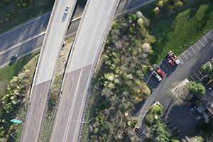
Aerial of a Maryland Highway with bradford pears and other vegetation beside the roadway

Bradford Pear Bloom

EA used a fixed-wing drone to document the Bradford Pear tree spring bloom along 15 miles of highway corridor. The hi-resolution images will be used to quantify the scope of the invasive species within the right-of-way.
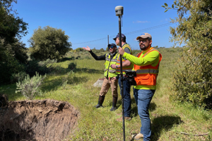
Engineers and scientists carrying survey equipment at the edge of an eroded stream bank

Fallbrook Creek

EA received funding from the DoD Legacy Resource Management Program to assess the threat of accelerated erosion and the feasibility of implementing nature-based erosion control projects in key areas for mission sustainment and protection of sensitive resources within the context of current and projected future climate stressors at Naval Weapons Station Seal Beach Detachment Fallbrook, CA. Erosion control treatments were developed as demonstration projects to evaluate their ability to stabilize the system from current degradative forces and buffer its capacity for increased resiliency during future storm events.
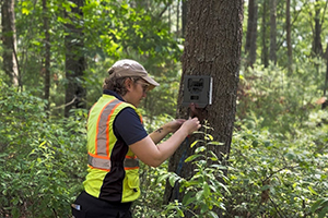
A scientist in field gear replaces the data storage in a trail camera attached to a tree located in a forested area

Big River Management Area

EA is developing a property management plan for the Big River Management Area, which spans over 8,400 acres. Work includes assessing and cataloging the site's infrastructure , documenting and developing recreational management strategies, assessing security and emergency vehicle access, and recommending and prioritizing implementation actions to guide the management of the area over the next 5 years. EA is employing a wide array of field and desktop methodologies, including trail condition assessments, automated trail monitoring, in-person site visits and surveys, and mapping applications.

×

Contact Us

EA Engineering, Science, and Technology, Inc., PBC headquarters
Name